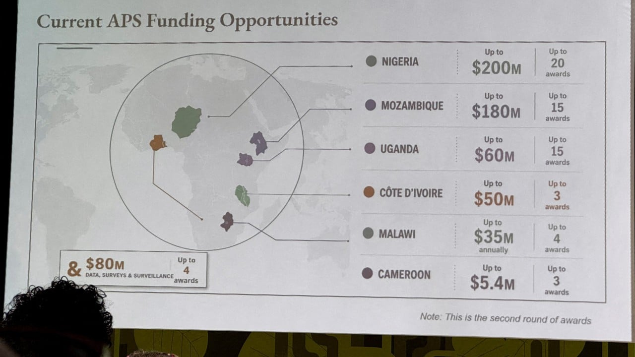
An institutional slide deck presented at a high-level global health summit in Rio de Janeiro featured a map of Africa where every highlighted country was mislabeled or misplaced. This graphic, utilized during a United States State Department briefing on international health partnership agreements, positioned coastal nations deep inside continental interiors and scrambled major geopolitical boundaries. Forensic digital analysis confirmed the graphic contained explicit artificial intelligence watermarks, tracing its origin directly to automated generation workflows.
The immediate fallout focused on the administrative embarrassment. However, a deeper audit of the workflow reveals a systemic collapse in quality control architecture, output verification, and risk management within public sector communications.
The Failure Architecture of Automated Visual Generation
The inclusion of an unverified artificial intelligence graphic in a formal diplomatic setting exposes three structural vulnerabilities within modern bureaucratic operations.
- The Velocity Mandate: Administrative environments increasingly prioritize speed of delivery over verification depth. When a team member executes a last-minute slide deck modification under acute time constraints, cognitive shortcuts replace standard validation protocols.
- The Hallucination Vector: Generative image tools compute probabilistic pixel arrangements rather than executing cartographic logic. When prompted to generate specialized geographic data layouts with overlapping categorical labels, these systems synthesize visually plausible fiction that bypasses spatial reality.
- The Verification Vacuum: Institutional hierarchies often treat visual media as decorative rather than data-bearing. Because vector graphics and charts are frequently exempted from the rigorous line-by-line editorial scrutiny applied to textual policy documents, errors pass undetected through multiple approval tiers.
These three variables converge to form an operational hazard. When automated tools are deployed without a human-in-the-loop verification constraint, the institution delegates its geographic and geopolitical accuracy to a stochastic algorithm.
The Cost Function of Cartographic Error in Diplomacy
Geopolitical representation carries heavy symbolic and operational weight. Deploying a map that relocates Nigeria into the Sahara Desert or shifts Mozambique to the Horn of Africa is not merely an aesthetic mishap. It damages institutional authority along three distinct vectors.
Analytical Credibility Collapse
Diplomatic negotiations depend on precision. When a government delegation presents partner nations with fundamental errors regarding their own geography, it signals an institutional disregard for regional realities. Partner governments invest political capital into bilateral frameworks; encountering basic administrative incompetence undermines trust in the seriousness of the overarching agreement.
Strategic Signaling Noise
In international development frameworks, such as the President's Emergency Plan for AIDS Relief, precise geographic allocation determines resource distribution, logistical deployment, and operational execution. If internal slide decks display structural confusion regarding target territories, external observers question whether the underlying program strategies suffer from similar analytical deficits.
The Amplification Loop of Digital Accountability
In contemporary operational environments, physical meetings are instantly digitized and broadcast across professional networks. Localized presentation errors no longer remain confined to the physical room. They are extracted, screenshotted, and analyzed by geopolitical commentators within hours, transforming an internal workflow failure into an international public relations liability.
Reengineering the Verification Pipeline
To eliminate structural exposure to synthetic media errors, public and private sector organizations must transition from reactive apologies to preventative operational design.
The first line of defense is the implementation of mandatory metadata filters. Presentation software and enterprise asset management systems must automatically flag or block digital assets containing generative watermarks unless explicitly cleared by a designated geographic information officer.
The second requirement is the enforcement of a strict separation between creative ideation and authoritative presentation. Generative tools possess utility for rapid prototyping or conceptual mockups, but they must remain strictly quarantined from final output generation in high-stakes environments. Every data-bearing graphic—particularly maps, demographic charts, and financial allocations—requires mandatory dual-signoff from a subject matter expert before deployment.
Organizations that fail to institutionalize these guardrails invite structural failure. Eliminating errors of this magnitude requires recognizing that generative visual tools are liability amplifiers when divorced from rigorous human oversight. The strategic remedy is not to abandon technological acceleration, but to construct unbreakable verification checkpoints that ensure digital output aligns with physical reality before it reaches the podium.

/GettyImages-157526585-93425538070d4422ad42d22af28c0758.jpg)