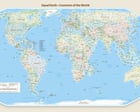
Cartography is never a neutral mathematical exercise; it is an administrative technology that codifies state power, territorial claims, and diplomatic reality. When the United Nations General Assembly adopted a resolution recommending the Equal Earth projection to correct the continental distortions inherent in legacy Mercator models, it triggered an unexpected administrative crisis. Tokyo’s subsequent diplomatic protest regarding the depiction of the Northern Territories—known in Russia as the Kuril Islands—exposes the fragile intersection where digital map design, international standards, and sovereign integrity collide.
The mechanics of this dispute center on visual semiotics. The Equal Earth projection, designed to render landmasses with correct relative areas, was implemented on digital platforms with specific color palettes to denote administrative control. By rendering the four disputed islands in the exact shade designated for Russian territory, alongside metadata characterizing effective Russian administration and Japanese sovereignty claims, the map generator bypassed a fundamental diplomatic red line for Tokyo.
This friction illustrates a primary principle of modern statecraft: passive visual depiction constitutes active legal erosion. For decades, Japan’s foreign policy regarding the Northern Territories has relied on maintaining a strict non-recognition stance toward Moscow's de facto administration established in 1945. When international bodies or digital cartographic tools normalize administrative control through chromatic grouping, they inadvertently manufacture a cognitive bias among global audiences. Chief Cabinet Secretary Minoru Kihara’s intervention via diplomatic channels targets this exact vulnerability, seeking to arrest the propagation of geographical misconceptions before they harden into accepted global norms.
The structural anatomy of the dispute reveals three distinct layers of friction:
- The Cartographic Variable: Digital map implementations must balance mathematical accuracy with complex geopolitical overlays, where color coding acts as a proxy for sovereignty rather than mere topographical data.
- The Diplomatic Asymmetry: International organizations vote on overarching resolutions—such as adopting area-accurate map standards—while failing to audit the granular design choices executed by third-party digital operators.
- The Escalation Vector: Cartographic disputes do not occur in a vacuum; they compound existing bilateral fractures, occurring closely on the heels of high-level state visits that already test the boundaries of diplomatic tolerance.
Addressing this challenge requires a systemic shift in how international administrative bodies vet digital representations. Standardization agencies must decouple the adoption of mathematical projections from the rendering of disputed boundaries, instituting automated neutrality protocols for territories subject to active sovereignty conflicts.
For diplomatic missions operating in environments defined by digital information warfare, monitoring map architecture is now as critical as tracking traditional treaty negotiations. Tokyo must operationalize an automated surveillance mechanism for global institutional media, ensuring that any future UN-backed cartographic framework defaults to disputed-boundary hashing rather than defaulting to the administrative color scheme of the occupying power.
国連推奨地図に修正申し入れ 北方領土をロシアと同色表現(2026年9月10日)
This video provides primary coverage and official Japanese government statements regarding the diplomatic protest lodged over the Equal Earth map's disputed territorial coloring.