Most travelers heading to Arizona make a predictable pilgrimage to the Grand Canyon. They crowd onto paved overlooks, snap the exact same smartphone photo, and leave thinking they've seen the state's best geological show. They haven't. Hidden away in the southeastern corner of the state lies an otherworldly maze of stone spires and balancing rocks that quietly transformed into America's newest national park.
Chiricahua National Monument officially became Chiricahua National Park, claiming its spot as the 64th national park in the country. For decades, this 19-square-mile pocket of southeastern Arizona remained a sleeper hit. It drew only about 60,000 visitors a year while massive parks wrestled with millions. That's about to change.
The Volcanic Recipe Behind the Land of Standing Up Rocks
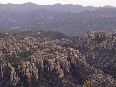
If you want to understand why Chiricahua looks so bizarre, you have to look back 27 million years. A catastrophic volcanic eruption known as the Turkey Creek caldera blew an unimaginable amount of ash and debris into the air. That hot ash welded together into a thick layer of rhyolite tuff.
Over millennia, water, ice, and wind eroded the rock along vertical and horizontal fractures. The result? Hundreds of towering stone columns, pinnacles, and balancing rocks that look like giant fingers frozen mid-reach. Native Americans historically referred to the area as the "Land of Standing-Up Rocks," while early white settlers dubbed it the "Wonderland of Rocks." Both descriptions are entirely accurate.
Walking among these stone columns feels like stepping onto a different planet. You won't find flat, monotonous desert floor here. You find deep canyons, shaded pine forests, and vertical spires that catch the shifting desert light and turn blazing orange, gold, and purple as the sun sets.
Navigating the Trails Without the Crowds
The biggest perk of visiting Chiricahua right now is the trail experience. Popular national parks have become endurance tests filled with traffic jams, packed parking lots, and crowded trails. Chiricahua offers actual solitude.
You can hike the Echo Canyon Trail or tackle the 8-mile Round Up loop and often see more deer and coatimundis than other hikers. The park features roughly 17 miles of day-hiking trails that wind right through the heart of the stone labyrinth.
Do yourself a favor and start early. The southeastern Arizona sun doesn't play around, even at higher elevations where temperatures are slightly more forgiving than the lower deserts. Pack plenty of water, wear sturdy boots because the volcanic gravel is slick, and keep your camera charged. Every turn reveals a stranger, more gravity-defying rock formation than the last.
Rich History and Cultural Significance
The landscape holds deep cultural weight that goes far beyond its geological appeal. The Chiricahua Apache people called these mountains home for generations, using the rugged maze as a natural stronghold and a place of spiritual sanctuary.
When you hike through the canyons, you are walking through a living landscape rich with history. Tribal leaders and conservation groups backed the push for national park status precisely to protect that deep connection while boosting local rural economies in nearby towns like Willcox and Douglas. It's a rare designation that bridges modern tourism demands with ancient respect for the land.
Birdwatching Capital You Didn't Know About
Beyond the rocks, Chiricahua is a hidden hot spot for wildlife. Because the mountain range acts as a "sky island"—a forested mountain rising out of a desert sea—it creates a unique collision of habitats.
You'll find species typical of both the American Southwest and Mexico living side by side. Birdwatchers flock here to spot elegant trogons, Mexican jays, and a dizzying variety of hummingbirds that dart through the sycamore trees. If you're lucky, you might spot a coatimundi roaming the forest floor with its long, ringed tail held straight up in the air.
Planning Your Trip Before the Secret Gets Out
Getting to Chiricahua takes a bit of effort, which is precisely why it stayed quiet for so long. It sits about two hours southeast of Tucson, far away from major interstate hustle.
Fly into Tucson International Airport, rent a car with good clearance, and drive down through the historic towns of Cochise County. You can camp right inside the park at the Bonita Canyon Campground, but sites fill up fast now that the park's profile has risen. Book months in advance or grab a motel room in nearby Willcox and make a day trip out of it.
Skip the overcrowded overlooks at the mega-parks this season. Grab your boots, head down to southeastern Arizona, and see the stone spires before the rest of the world catches on.