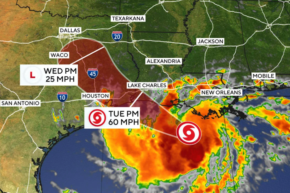
Gulf Coast residents know the drill by heart. A system spins up over warm water, the local news anchors roll up their sleeves, and everyone starts eyeing grocery store water aisles with quiet suspicion. Tropical Storm Edouard is currently making that exact script play out live across the upper Texas and southwestern Louisiana coasts.
If you live anywhere along the I-45 corridor or near the bayous, you shouldn't just brush this off as a standard afternoon thunderstorm. The National Hurricane Center and the Weather Prediction Center have made it clear that heavy rainfall and flash flooding are the main threats as Edouard pushes inland.
What the Track and Rainfall Maps Are Actually Telling You
Edouard formed quickly in the Gulf of Mexico, packing sustained winds right around the tropical storm threshold. While wind gusts are causing localized headaches, water is the real enemy here.
Current forecasts from meteorologists point to a widespread 3 to 6 inches of rain across the upper Texas coast and east-central Texas. In some spots, localized totals could spike up to 9 inches. That kind of water volume doesn't drain gracefully. It pools, it rises, and it turns familiar neighborhood intersections into unnavigable lakes within a matter of hours.
The primary hazard comes down to the storm's slow forward speed. Edouard isn't racing across the map. It's crawling. That sluggish movement means heavy rainbands are repeating over the exact same saturated ground—a phenomenon meteorologists call training. When boxcar-style rainbands keep pounding the same stretch of highway or subdivision, drainage systems fail instantly.
A tropical storm warning stretches from Port Bolivar in Texas over to the Vermilion/Cameron Parish line in Louisiana. At the same time, storm surge watches warn that coastal areas could see water climbing up to 5 feet above normal ground level.
Surviving the Sods and Avoiding Flash Floods
Most people panic about wind damage and board up windows only to find their living rooms knee-deep in water because they underestimated street-level drainage limits. Flash flooding catches drivers off guard every single time.
If you are out on the roads and encounter standing water, turn around. It is genuinely that simple. It takes less than two feet of rushing water to sweep a full-sized vehicle away. Urban and low-lying areas from Houston northward toward east-central Texas are under a level 2 out of 4 risk for excessive rainfall. That means scattered to numerous flash flood events are expected before the system finally weakens and dissipates inland.
Keep your phones charged, monitor local radar feeds closely for sudden warning updates, and move any vehicles parked in chronic flood zones to higher ground right now. Do not wait for water to pool in your driveway before taking action.